EOC Logo
  • About
  • News
  • Services
  • Maps ▾
    TanDEM-X 30m Edited Digital Elevation Model (EDEM) TanDEM-X 30m DEM Change Maps (DCM) TanDEM-X 90m DEM TanDEM-X PolarDEM 90m of Antarctica TanDEM-X Forest/Non-Forest Map SRTM X-SAR DEM
    EnMAP L0 Quicklooks
    Burnt Area Daily NRT Incremental Product - Europe, MODIS Burnt Area Daily NRT Incremental Product - Europe, Sentinel-3 Burnt Area Monthly Composite - Europe, Sentinel-3 Burnt Area Yearly Composite - Europe, Sentinel-3
    CropTypes - Crop Type Maps for Germany - Yearly, 10m GrassLands - Mowing Dynamics - Germany, 10m HedgeRows - Bavaria, 2019-2021
    MetOp GOME-2 Level 3 Daily Total Column Composites Sentinel-5P TROPOMI L3 Daily Composites Sentinel-5P TROPOMI L4-DE Daily Composites
    MODIS-EU Daily Mosaic MODIS-DE Mosaic
    Sentinel-2 L2A MAJA Products Sentinel-2 L3A WASP Products
    World Settlement Footprint (WSF) - Landsat-8/Sentinel-1 - Global, 2015 World Settlement Footprint (WSF) - Sentinel-1/Sentinel-2 - Global, 2019 World Settlement Footprint (WSF) Evolution World Settlement Footprint (WSF) 3D - Global, 90m
    GUF® - Global Urban Footprint® v1 - EPSG:3857 (WGS 84 / Pseudo-Mercator) GUF® - Global Urban Footprint® v1 - EPSG:4326 (WGS84 / geocentric)
    GWP - Global WaterPack Yearly GWP - Global WaterPack Monthly SWIM Water Extent
    GSP - Global SnowPack Yearly GSP - Global SnowPack Daily GSP - Global SnowPack Mean
    TimeScan Landsat 2015
    Forest Canopy Cover Loss (FCCL) - Germany - Monthly, 10m Forest Canopy Cover Loss (FCCL) - Germany - Monthly, Administrative Level Forest Structure - Germany, Yearly Tree Canopy Cover Loss - Germany, 2018-2021 Tree Species - Sentinel-1/2 - Germany, 2022
    AVHRR - Monthly Sea Surface Temperature
    TIMELINE Level 3 - Monthly (1982-2022)
    IceLines - Ice Shelf and Glacier Front Time Series
    CORINE Land Cover Land Cover DE Road Traffic Noise - Germany, 2017 Road Traffic Noise (AI Prediction) - Germany, 2017
    RapidEye RESA - L3M Mosaic - Germany
    S-VELD S5P Trop. NO2 Columns (Daily/Orbit) S-VELD S5P Trop. NO2 Columns (Monthly Mean) S-VELD S5P Surface NO2 (Daily/Orbit) S-VELD S5P Surface NO2 (Monthly Mean) S-VELD MODIS/SLSTR Surface PM2.5 (Monthly Mean)
    Soil Composite Mapping Processor (SCMaP) Products (5 years) Soil Composite Mapping Processor (SCMaP) Products (30 years) SoilSuite - Sentinel-2 - Europe, 5 year composite (2018-2022) SoilSuite - Sentinel-2 - Africa, 4 year composite (2018-2021)
    UrMo Digital - Traffic Area Map (TAM) - Brunswick, Germany
    Geo-ForPy - Forest cover Paraguayan Chaco
    Residential Heat Demand - Baden Württemberg, Germany
    SAR4Tectonics (S4T)
    ECoLaSS - Evolution of Copernicus Land Services based on Sentinel Data
    fCover - Fractional Vegetation Cover Netherlands based on Sentinel-2 Data
  • Downloads ▾
    EnMAP - Environmental Mapping and Analysis Program DESIS - DLR Earth Sensing Imaging Spectrometer
    fCover Sentinel-2 Netherlands
    Forest Canopy Cover Loss Germany Forest Structure Germany Tree Species Germany
    Geo-ForPy - Forest Cover Paraguayan Chaco
    CropTypes - Crop Type Maps for Germany GrassLands - Mowing Dynamics HedgeRows - Bavaria, 2019-2021
    GWP - Global WaterPack SWIM - Surface Water Inventory and Monitoring (SWIM) Water Extent
    GSP - Global SnowPack
    IceLines - Ice Shelf and Glacier Front Time Series PolarLakes - Sentinel-1/2 - Antarctica
    Land Cover DE
    Sentinel-2 L2A MAJA Sentinel-2 L3A WASP Sentinel-5p Tropomi
    S-VELD NO2 and PM2.5
    SOILSUITE
    SRTM X-SAR DEM
    TanDEM-X 30m Edited Digital Elevation Model (EDEM) TanDEM-X 30m DEM Change Maps (DCM) TanDEM-X 90m DEM TanDEM-X Forest/Non-Forest Map TanDEM-X PolarDEM Antarctica
    TerraSAR-X Supersites
    TIMELINE Level 3 - Monthly (1982-2022)
    Tree Canopy Cover Loss - Germany, 2018-2021
    UrMo Digital - Traffic Area Map (TAM) - Brunswick, Germany
    World Settlement Footprint 2015 World Settlement Footprint 2019 World Settlement Footprint Evolution World Settlement Footprint 3D World Settlement Footprint 3D Material Stock
  • Data Guides ▾
    SRTM X-SAR DEM TanDEM-X 30m EDEM and DCM TanDEM-X 90m DEM TanDEM-X FNF 50m
DLR Logo
null

TanDEM-X - Edited Digital Elevation Model (EDEM) - Global, 30m

Thumbnail - TDM30_EDEM

Abstract

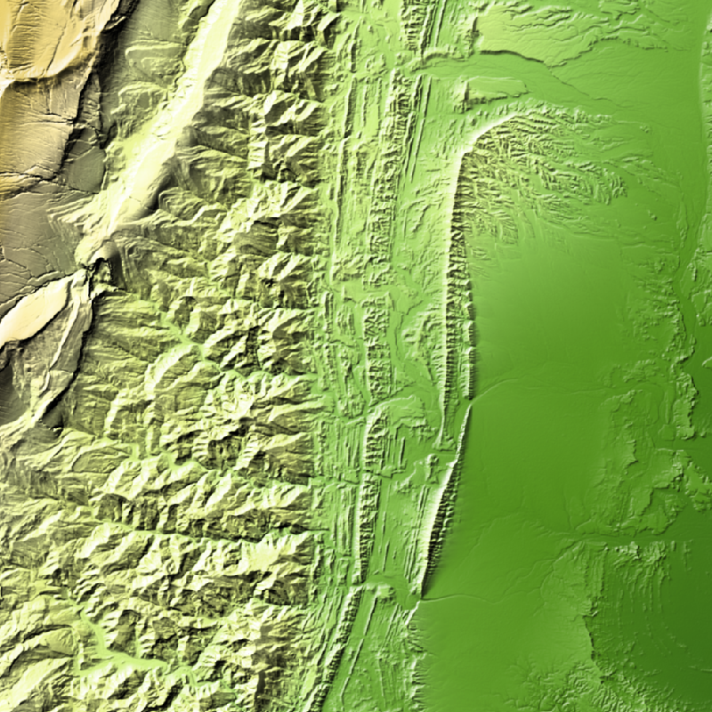
TanDEM-X (TerraSAR-X add-on for Digital Elevation Measurements) is an Earth observation radar mission that consists of a SAR interferometer built by two almost identical satellites flying in close formation. With a typical separation between the satellites of 120 m to 500 m a global Digital Elevation Model (DEM) has been generated.
The TanDEM-X 30m EDEM is a product variant of the global Digital Elevation Model (DEM) acquired in the frame of the German TanDEM-X mission between 2010 and 2014, and has a reduced pixel spacing of 1 arcseconds (arsec), which corresponds to 30m at the equator. An automated edition was developed by the Microwaves and Radar Institute at the German Aerospace Center (DLR) to have a full and clean coverage of all Earth’s landmasses from pole to pole.

Contact

  • tandemx-science@dlr.de
    German Aerospace Center (DLR)
  • geoservice@dlr.de
    German Aerospace Center (DLR)

Keywords

  • DLR
  • TDM
  • HR
  • TanDEM-X
  • EDEM
  • DEM
  • Digital Elevation Model
  • TDX-1
  • TSX-1
  • TDM 30m EDEM
  • Edited DEM
  • Global
  • GEMET - INSPIRE themes, version 1.0
  • Elevation
  • Spatial scope
  • Global

License

  • Nutzungseinschränkungen: Das DLR ist nicht haftbar für Schäden, die sich aus der Nutzung ergeben. / Use Limitations: DLR not liable for damage resulting from use.
  • Nutzungsbedingungen Terms of Use: https://geoservice.dlr.de/resources/licenses/tdm30-edited/License_for_the_Utilization_of_TanDEM-X_30m-EDEM_DCM_for_Scientific_Use.pdf

Links

  • Download Metadata (.xml)

Last Update: 2024-06-27

Please wait...

Download

Select Items:

Keep Ctrl pressed to select Bounding Box.


No items selected


time limit
1 month
Year Month Day Custom
--
to
--

Custom Interval

Geoservice

Contact | Privacy | Terms | Imprint

Partner

DLR Portal | EOC Portal | EOWEB© GeoPortal