EOC Logo
  • About
  • News
  • Services
  • Maps ▾
    TanDEM-X 30m Edited Digital Elevation Model (EDEM) TanDEM-X 30m DEM Change Maps (DCM) TanDEM-X 90m DEM TanDEM-X PolarDEM 90m of Antarctica TanDEM-X Forest/Non-Forest Map SRTM X-SAR DEM
    EnMAP L0 Quicklooks
    Burnt Area Daily NRT Incremental Product - Europe, MODIS Burnt Area Daily NRT Incremental Product - Europe, Sentinel-3 Burnt Area Monthly Composite - Europe, Sentinel-3 Burnt Area Yearly Composite - Europe, Sentinel-3
    CropTypes - Crop Type Maps for Germany - Yearly, 10m GrassLands - Mowing Dynamics - Germany, 10m HedgeRows - Bavaria, 2019-2021
    MetOp GOME-2 Daily Total Column Composites Sentinel-5P TROPOMI L3 Daily Composites Sentinel-5P TROPOMI L4-DE Daily Composites
    MODIS-EU Daily Mosaic MODIS-DE Mosaic
    Sentinel-2 L2A MAJA Products Sentinel-2 L3A WASP Products
    World Settlement Footprint (WSF) - Landsat-8/Sentinel-1 - Global, 2015 World Settlement Footprint (WSF) - Sentinel-1/Sentinel-2 - Global, 2019 World Settlement Footprint (WSF) Evolution World Settlement Footprint (WSF) 3D - Global, 90m
    GUF® - Global Urban Footprint® v1 - EPSG:3857 (WGS 84 / Pseudo-Mercator) GUF® - Global Urban Footprint® v1 - EPSG:4326 (WGS84 / geocentric)
    GWP - Global WaterPack Yearly GWP - Global WaterPack Monthly SWIM Water Extent
    GSP - Global SnowPack Yearly GSP - Global SnowPack Daily GSP - Global SnowPack Mean
    TimeScan Landsat 2015
    Forest Canopy Cover Loss (FCCL) - Germany - Monthly, 10m Forest Canopy Cover Loss (FCCL) - Germany - Monthly, Administrative Level Forest Structure - Germany, Yearly Tree Canopy Cover Loss - Germany, 2018-2021 Tree Species - Sentinel-1/2 - Germany, 2022
    AVHRR - Monthly Sea Surface Temperature
    TIMELINE Level 3 - Monthly (1982-2022)
    IceLines - Ice Shelf and Glacier Front Time Series
    CORINE Land Cover Land Cover DE Road Traffic Noise - Germany, 2017
    RapidEye RESA - L3M Mosaic - Germany
    S-VELD S5P Trop. NO2 Columns (Daily/Orbit) S-VELD S5P Trop. NO2 Columns (Monthly Mean) S-VELD S5P Surface NO2 (Daily/Orbit) S-VELD S5P Surface NO2 (Monthly Mean) S-VELD MODIS/SLSTR Surface PM2.5 (Monthly Mean)
    Soil Composite Mapping Processor (SCMaP) Products (5 years) Soil Composite Mapping Processor (SCMaP) Products (30 years) SoilSuite - Sentinel-2 - Europe, 5 year composite (2018-2022) SoilSuite - Sentinel-2 - Africa, 4 year composite (2018-2021)
    UrMo Digital - Traffic Area Map (TAM) - Brunswick, Germany
    Geo-ForPy - Forest cover Paraguayan Chaco
    Residential Heat Demand - Baden Württemberg, Germany
    SAR4Tectonics (S4T)
    ECoLaSS - Evolution of Copernicus Land Services based on Sentinel Data
    fCover - Fractional Vegetation Cover Netherlands based on Sentinel-2 Data
  • Downloads ▾
    EnMAP - Environmental Mapping and Analysis Program DESIS - DLR Earth Sensing Imaging Spectrometer
    fCover Sentinel-2 Netherlands
    Forest Canopy Cover Loss Germany Forest Structure Germany Tree Species Germany
    Geo-ForPy - Forest Cover Paraguayan Chaco
    CropTypes - Crop Type Maps for Germany GrassLands - Mowing Dynamics HedgeRows - Bavaria, 2019-2021
    GWP - Global WaterPack SWIM - Surface Water Inventory and Monitoring (SWIM) Water Extent
    GSP - Global SnowPack
    IceLines - Ice Shelf and Glacier Front Time Series PolarLakes - Sentinel-1/2 - Antarctica
    Land Cover DE
    Sentinel-2 L2A MAJA Sentinel-2 L3A WASP Sentinel-5p Tropomi
    S-VELD NO2 and PM2.5
    SOILSUITE
    SRTM X-SAR DEM
    TanDEM-X 30m Edited Digital Elevation Model (EDEM) TanDEM-X 30m DEM Change Maps (DCM) TanDEM-X 90m DEM TanDEM-X Forest/Non-Forest Map TanDEM-X PolarDEM Antarctica
    TerraSAR-X Supersites
    TIMELINE Level 3 - Monthly (1982-2022)
    Tree Canopy Cover Loss - Germany, 2018-2021
    UrMo Digital - Traffic Area Map (TAM) - Brunswick, Germany
    World Settlement Footprint 2015 World Settlement Footprint 2019 World Settlement Footprint Evolution World Settlement Footprint 3D World Settlement Footprint 3D Material Stock
  • Data Guides ▾
    SRTM X-SAR DEM TanDEM-X 30m EDEM and DCM TanDEM-X 90m DEM TanDEM-X FNF 50m
DLR Logo

TanDEM-X - DEM Change Maps (DCM) - Global, 30m

Thumbnail - TDM30_DCM

Abstract

The TanDEM-X DEM Change Maps is a project developed by the Institute Remote Sensing Technology (IMF) at the German Aerospace Center (DLR) within the activities of the TanDEM-X Mission.
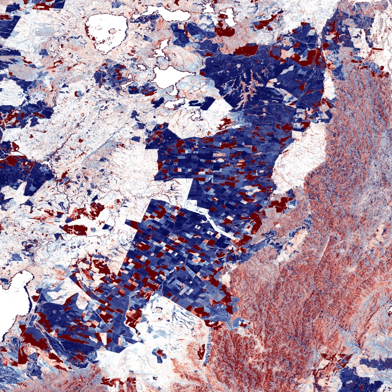
Between 2016 and 2022, the TanDEM-X mission acquired an additional complete coverage of the Earth's landmass to deliver a temporally independent coverage within a well-defined time span. These new acquisitions not only provide more up-to-date elevation information, but also a great dataset to show the changes that have occurred during the years separating this new coverage from the coverages acquired to generate the TanDEM-X global DEM (between 2011 and 2014). This product - the TanDEM-X 30 m DEM Change Maps - shows the changes between the edited first global TanDEM-X DEM (TanDEM-X 30m Edited DEM) and the newly acquired time-tagged DEM scenes. In order to keep a unique timestamp, two change maps are available per tile: one with the change to the oldest pixel in the new dataset - the first DEM change, and another with the change to the newest pixel of the new dataset - the last DEM change. The two maps differ only when there are multiple coverages.
Users must be aware that a given elevation change measured in the DEM change maps corresponds to a topographic change with respect to TanDEM-X 30m EDEM, but cannot be associated with a corresponding physical height change of the same magnitude. This is due to the fact that the global TanDEM-X DEM reflects an averaged elevation derived from the combination of different images, acquired over a period of several years but also because the radar waves penetrate differently in the surface depending on the attributes of the land cover. This is especially important over vegetated and snow-covered regions.

Contact

  • tandemx-science@dlr.de
    German Aerospace Center (DLR)
  • geoservice@dlr.de
    German Aerospace Center (DLR)

Keywords

  • DLR
  • IMF
  • EOC
  • TanDEM-X
  • DEM Change Maps
  • Change
  • Change Detection
  • Digital Elevation Model
  • TDM 30m DCM
  • TanDEM-X 4D
  • TDX-1
  • TSX-1
  • Global
  • inspireidentifiziert
  • GEMET - INSPIRE themes, version 1.0
  • Elevation
  • Spatial scope
  • Global

License

  • Nutzungseinschränkungen: Das DLR ist nicht haftbar für Schäden, die sich aus der Nutzung ergeben. / Use Limitations: DLR not liable for damage resulting from use.
  • Nutzungsbedingungen Terms of Use: https://geoservice.dlr.de/resources/licenses/tdm30-edited/License_for_the_Utilization_of_TanDEM-X_30m-EDEM_DCM_for_Scientific_Use.pdf

Links

  • Download Metadata (.xml)

Last Update: 2024-06-27

Please wait...

Download

Select Items:

Keep Ctrl pressed to select Bounding Box.


No items selected


time limit
1 month
Year Month Day Custom
--
to
--

Custom Interval

Geoservice

Contact | Privacy | Terms | Imprint

Partner

DLR Portal | EOC Portal | EOWEB© GeoPortal